


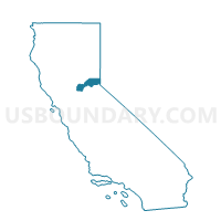
Voting District 50015, Placer County, California
About
Outline

Summary
| Unique Area Identifier | 536751 |
| Name | Voting District 50015 |
| County | Placer County |
| State | California |
| Area (square miles) | 8.18 |
| Land Area (square miles) | 8.18 |
| Water Area (square miles) | 0.00 |
| % of Land Area | 100.00 |
| % of Water Area | 0.00 |
| Latitude of the Internal Point | 38.99501690 |
| Longtitude of the Internal Point | -121.12026830 |
Maps


Graphs
Select a template below for downloading or customizing gragh for Voting District 50015, Placer County, California


Neighbors
Neighoring Voting District (by Name) Neighboring Voting District on the Map
- Voting District 20085, Nevada County, CA
- Voting District 50020, Placer County, CA
- Voting District 50025, Placer County, CA
- Voting District 50040, Placer County, CA
- Voting District 50045, Placer County, CA
- Voting District 50050, Placer County, CA
- Voting District 50065, Placer County, CA
- Voting District 50080, Placer County, CA
- Voting District 50085, Placer County, CA
- Voting District 50165, Placer County, CA
- Voting District 50175, Placer County, CA
- Voting District 50260, Placer County, CA
Top 10 Neighboring County Subdivision (by Population) Neighboring County Subdivision on the Map
Top 10 Neighboring Elementary School District (by Population) Neighboring Elementary School District on the Map
- Auburn Union Elementary School District, CA (33,064)
- Pleasant Ridge Union Elementary School District, CA (20,577)
- Placer Hills Union Elementary School District, CA (13,646)
Top 10 Neighboring Secondary School District (by Population) Neighboring Secondary School District on the Map
Top 10 Neighboring State Legislative District Lower Chamber (by Population) Neighboring State Legislative District Lower Chamber on the Map
Top 10 Neighboring State Legislative District Upper Chamber (by Population) Neighboring State Legislative District Upper Chamber on the Map
Top 10 Neighboring 111th Congressional District (by Population) Neighboring 111th Congressional District on the Map
Top 10 Neighboring Census Tract (by Population) Neighboring Census Tract on the Map
- Census Tract 1.03, Nevada County, CA (7,893)
- Census Tract 218.01, Placer County, CA (4,522)
- Census Tract 216.04, Placer County, CA (3,161)
- Census Tract 1.05, Nevada County, CA (2,792)